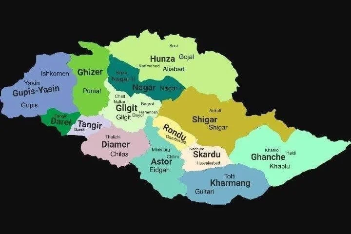
Gilgit Baltistan Map
Gilgit-Baltistan is one of the most beautiful regions of Pakistan. It is located in the northern part of the country and was once known as the Northern Areas of Pakistan. The region is managed by Pakistan and has its own local government. However, Gilgit-Baltistan has also been a disputed area between Pakistan and India because it forms part of the greater Kashmir region.
According to the Gilgit Baltistan map, this area shares borders with many regions. It is bordered by Azad Kashmir in the south, Khyber Pakhtunkhwa in the west, Afghanistan’s Wakhan Corridor in the north, and China’s Xinjiang in the east. On the southeastern side, it borders the Indian-administered Jammu and Kashmir and Ladakh regions.
Formation of Gilgit-Baltistan as an Administrative Region
Gilgit-Baltistan became an individual administrative area in 1970 and was called the “Northern Areas.” Later, in 2009, it was renamed Gilgit-Baltistan. The change came after the Self-Governance Order signed by former president Asif Ali Zardari, which gave limited self-rule to the people of the region.
Geography and Surroundings
Looking at the Gilgit Baltistan map, you’ll see it is a land of mighty mountains. It is home to K2, the second-highest mountain in the world, and several other peaks above 8,000 meters. The total area of Gilgit-Baltistan is about 72,971 square kilometers. It is divided into three main divisions — Gilgit, Baltistan, and Diamer, which together include fourteen districts.
Baltistan Division
Baltistan Division includes five districts: Skardu, Ghanche, Shigar, Kharmang, and Rondu. The capital of this division is Skardu, a popular tourist destination surrounded by mountains, lakes, and valleys.
Skardu District
Skardu covers about 8,700 square kilometers. It is surrounded by Ghanche, Kharmang, Astore, Rondu, and Shigar districts. Famous tourist spots here include Shangrila Resort, Upper Kachura Lake, Lower Kachura Lake, and Sheosar Lake. Major towns include Skardu city, Hussainabad, Mehdiabad, Qumarah, and Sermik.
Ghanche District
Located in the eastern part of Baltistan, Ghanche covers around 4,052 square kilometers. Its main town, Khaplu, is one of the most scenic places in Pakistan. Ghanche is known for its stunning landscapes, Khaplu Fort, and as a base for many trekkers heading toward high-altitude peaks. The district has three tehsils — Khaplu, Daghoni, and Mashabrum.
Shigar District
Shigar was once part of Skardu but became a separate district in 2015. Covering 8,500 square kilometers, it is home to K2, the world’s second-highest mountain. The district borders Hunza, Nagar, Ghanche, Rondu, and Gilgit districts.
Kharmang District
Kharmang borders Skardu, Ghanche, Kargil, and Astore. Its headquarters are in Tolti, and the district covers 5,500 square kilometers. The famous Kharmang Valley is among the most beautiful spots in Baltistan.
Rondu District
Created in 2019, Rondu was previously part of Skardu. Its main town is Dambudas, about 65–70 kilometers from Skardu city. The area is known for its wide valleys and scenic views.
Gilgit Division
The Gilgit Division includes five districts: Gilgit, Ghizer, Hunza, Nagar, and Gupis-Yasin. The capital is Gilgit city.
Gilgit District
This district covers 14,672 square kilometers. It borders Nagar, Shigar, Diamer, and Ghizer. Gilgit city, the headquarters, is a hub for trade and tourism.
Ghizer District
Covering 9,635 square kilometers, Ghizer was restructured in 2019. It borders Upper Chitral, Wakhan, Hunza, and Tangir. Major tehsils are Ishkoman and Punial, and the main town is Gahkuch.
Hunza District
Hunza was formed in 2015 after separation from the Hunza-Nagar district. It covers 7,900 square kilometers, and its headquarters are in Aliabad. Karimabad is another major tourist town famous for Baltit Fort and Altit Fort.
Nagar District
Also created in 2015, Nagar covers 5,000 square kilometers. It borders Hunza, Shigar, Gilgit, and Gupis-Yasin. The district includes two tehsils: Nagar-I and Nagar-II, with Nagarkhas as its main town.
Gupis-Yasin District
Formed in 2019, Gupis-Yasin is bounded by Upper Chitral, Ghizer, and Swat districts. The district’s capital is Phander, famous for Phander Lake. It has three tehsils: Gupis, Phander, and Yasin.
Diamer Division
The Diamer Division has four districts — Diamer, Astore, Darel, and Tangir. The capital is Chilas, a historic town located along the Karakoram Highway.
Diamer District
Covering 10,936 square kilometers, Diamer is surrounded by Tangir, Astore, and Naran. The area is famous for its rock carvings and serves as a gateway to Gilgit-Baltistan from the south.
Astore District
Astore covers around 5,092 square kilometers, with Eidgah as its headquarters. The district is full of glaciers, valleys, and green meadows. It borders Gilgit, Rondu, Skardu, Kharmang, and Diamer.
Darel and Tangir Districts
Both Darel and Tangir were created in 2019 after separation from Diamer. Darel borders Ghizer, Gilgit, and Upper Kohistan, while Tangir is surrounded by Gupis-Yasin, Ghizer, Darel, and Upper Kohistan. These areas are known for their natural beauty and traditional mountain life.
Why Visit Gilgit-Baltistan
From high mountains to green valleys, lakes, and rivers — Gilgit-Baltistan is full of natural beauty. It’s a perfect destination for adventure lovers, hikers, and those who simply want to enjoy peaceful landscapes. When you look at the Gilgit Baltistan map, you can see how every valley offers something different — from Skardu’s lakes to Hunza’s forts and Astore’s meadows.
Contact Us to Visit Gilgit-Baltistan
We are Youtouria, and we offer custom travel packages to explore the best places shown on the Gilgit Baltistan map, from Skardu and Hunza to Astore and Khaplu.
Contact us today to plan your next trip to this beautiful northern region of Pakistan.